Owyhee River (OR) - May 8-12, 2017 - 68 Miles
Please be patient while the pictures load...
Trip Itinerary (BLM map for Lower Owyhee):
Day Camp Bank River Mile (RM)
Put-in Rome,OR Right 0.0
1 Little Hackberry Left 15.5
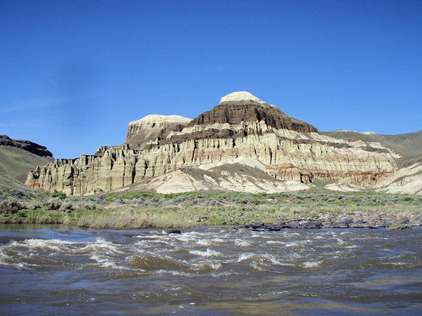
2 Pruitt's Castle Left 24.5
3 Jackson Hole Left 37.5
4 Nr Island Ranch WW Left 54.5
Takeout Leslie Gulch Right 68.0

Camping at the Rome putin. Lots of people here this year. Got down to 30F overnight. Tent fly condensation was actually frozen. Previous trip was in 2002

Morning rigging, before the rest of the crowds appear

On the water at 11:05am MDT. The Owyhee is in the small eastern part of Oregon that is not PDT

Looking downstream towards the US 95 bridge

Bird condos under the bridge

One of the few riffles on the first day

Slow moving flat water

Casey took an alternate path

Below Jordan Creek. Antelope Reservoir upstream sometimes adds minor inflows to the Rome gage

Horses grazing on the hill

Verification photo. Thanks Terri!

Whitewater with a view

More whitewater with a view

Hikeout camp was taken

Took Little Hackberry instead

Sandy tenting area

Day 2 - Looking upstream from camp 9:52am. Almost ready to launch

Weeping Wall RM 17.5. Several water containers were refilled here and thus began the argument as to whether or not it was safe to drink

Upstream of Weeping Wall

Mike and Chris, the 2 kayakers

Just admiring the view

Jim and Thomas

Isolated rock spires

View above Pruitt's Castle

Shared group camp at Pruitt's Castle

Across from Pruitt's Castle

Fuzzy moon rise

Day 3- Sun rises on Pruitt's Castle

Morning hike to Pruitt's Castle

Stitched 2 frame panorama at Pruitt's Castle

Terrain behind

More Pruitt's Castle

More rock spires

On the water at 10:19am passing Pruitt's Castle

Chalk Basin #1
Chalk Basin #2

Awed by the everchanging formations

Canyon tightens

Above Whistling Bird

Below Whistling Bird rapid

Bridge gap

Cliff Side camp below Montgomery

Looking back at Montgomery

Relax and float

Jackson Hole camp. Kitchen was setup under the trees so we didn't have to put up a shade tarp like we did at Pruitt's Castle

Day 4 - On the water at 10:15am

Spires at the top and V-shaped fill area

Relaxing ....

Passing Hole-In-The-Ground Ranch

The Owyhee's Devils Tower

Greeley Bar hot springs

Casey admires the rock formations

Definitely unique

Still in awe of the changes

Passing first Water Wheel RM 50

Another group already parked at Basque camp

Passing SUP boarder with another group

Camp rattlesnake

Camping across from defunct Island Ranch
Water Wheel. Looks like major channel changes moved it away from main flow

Downstream of camp

Upstream of camp

Pinnacle Rock behind camp. Several of the group hiked up there

Day 5 - After a few miles of rowing in the rain, we started the group trip in the slackwater to the takeout. Note wake under tubes. Going about 4.25mph

View from Casey's end. Verification photo

Lake Owyhee. Damn water spot from rain. 12:14pm

Casey pushes the tied togther rafts with his outboard


Still got that damn water spot

More spires

Approaching Leslie Gulch takeout 2:05pm

Group shot at Leslie Gulch from Thomas. Actually taken by gal on SUP board

05/08/2017 12:00 MDT 3,580 CFS 5.22'
05/12/2017 12:00 MDT 2,840 CFS 4.63'

Flow below Wild Horse Reservoir (near SNOTEL source)
05/08/2017 12:00 PDT 298 CFS 2.77'
05/12/2017 12:00 PDT 277 CFS 2.69'
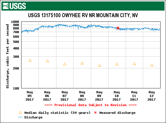
20 miles below Wild Horse (still 100+ miles upstream from Rome)
05/08/2017 12:00 PDT 7.16' 863 CFS
05/12/2017 12:00 PDT 6.96' 788 CFS
Credits:
- U.O.N., Olympus Stylus 770SW Digital Photography by William F. Smith (7.1 MP, 3072x2304 HQ, 3X optical 38-114mm)