Upper-Middle Sauk River (WA) - June 4-5, 2016
Please be patient while the pictures load...

Rigging at Bedal Campground. Just Jim and I this weekend

Just downstream of launch. On the water at 12:41pm

Looking back to make sure Jim got off ok

Confluence of North and South Fork Sauk

Just below confluence there is a log across the left channel that forces us to use the lower water right channel

Jim weaves thru the rocks

And makes it thru cleanly

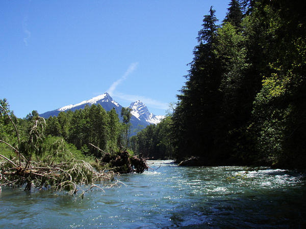
The upper Sauk valley scenery is spectacular

Looking upstream

Bedal and Sloan Peaks (elev. 6554 ft. and 7839 ft.)

Verification photo. Forgot the river shorts. Makes it difficult when wearing the wetsuit at half-mast2
Wandering thru a new river channel. At this point we aren't sure where we camped in earlier years

Was forced to camp on a small bench landing just above the USGS gaging station, which is only minutes above Whitechuck.
The campsite we took was >1.5 miles below the 'old' one

The small camp had great afternoon shade, but we set up the tarp in anticipation of being baked by the morning sun

Mt. Pugh close-up (elev. 7201 ft.)
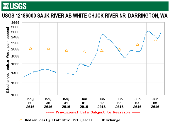
USGS Flow at 06/04/2016 12:00 PDT 1,930 CFS 4.25'

Next morning, baking in the sun as expected

On the water at 10:58am

Checking the gage level2

Just above Whitechuck confluence

After doing part 2 of the shuttle, we unloaded the camping equipment. On the water again at 12:57pm

Jim thru Alligator. Water was unexpectedly high today. Quite pushy

With lots of water Jim tried the old Whirlpool channel, and I proved once again it's not good taking pictures into the sun :)

Lunch stop in the shade below Popeye. Wearing a wetsuit in 90+ heat requires lots of hydration

USGS Flow at 06/05/2016 12:00 PDT 8,190 CFS 6.32'

USGS Flow at 06/05/2016 12:00 PDT 3,680 CFS 7.57'
3680/8190 = 45% of Sauk flow
Credits:
- U.O.N., Olympus Stylus 770SW Digital Photography by William F. Smith (7.1 MP, 3072x2304 HQ, 3X optical 38-114mm)
- Olympus Stylus 725SW Digital Photography by Jim McCool (7.1 MP, 3X optical 38-114mm)